Spatial Strategy Zoetermeer
Zoetermeer then, now and soon. From a village community then to a society of about 130,000 inhabitants now. A city that never stands still. What developments in the city are ensuring that Zoetermeer now and in the future will remain a place where it is pleasant to live, recreate, work and do business? The developments now, influence our city later. A city where everyone feels welcome and at home.
On October 28, 2025, the Zoetermeer City Council adopted the Spatial Strategy Zoetermeer 2040. The Spatial Strategy is the second part of Zoetermeer's environmental vision. The environmental vision has theZoetermeer 2040 Visionas part 1. Whereas the Zoetermeer 2040 Vision is still a broad outline, the Spatial Strategy maps out how and where we are going to implement the environmental vision.
The Spatial Strategy builds on the outlines identified in the Vision Zoetermeer 2040. The strategy contains the plans for the city. Important topics such as housing, mobility, energy, green and economy are addressed. The Spatial Strategy is not a sum of solutions, but a picture of the future for the city. View the pdf file of the Spatial Strategy here. The environmental vision (Vision Zoetermeer 2040 + Spatial Strategy) is also available digitally interactively via: Regels op de Kaart - Omgevingsvisie gemeente Zoetermeer.
Spatial Strategy Zoetermeer 2040 - City in the neighborhood!
The Spatial Strategy shows where we as a city are heading if we make the most of the opportunities and challenges. We seek space for housing, facilities and work mainly in the existing city. In this way we strengthen the most accessible places in the city and with the addition we also ensure the renewal of areas that are now becoming worn out. In the central areas such as Entrance and the city center, most buildings will be added. In most of the quiet (suburban) residential areas, new construction takes place mainly in the shopping centers, which can also be refurbished as a result. This allows the downtown to grow.
Vision map Zoetermeer: City in the neighborhood
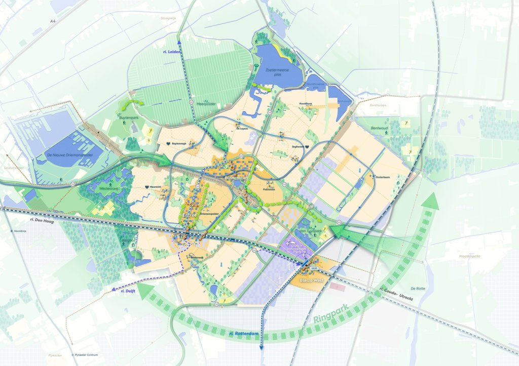
In the image above, you can see the strength of Zoetermeer captured in one image. A city close to the largest cities in the Netherlands. A city with fine neighborhoods where everything is close by because it is compactly built around all the amenities that make urban life attractive. And which at the same time is directly connected to the peace and space of the green heart. That makes Zoetermeer "the city nearby.
10 strategic choices
10 spatial strategic choices are made for the city. These are:
- Together we strengthen the strength of the region
- We build within the existing city and concentrate urbanity
- We strengthen the spatial identity of New Town Zoetermeer
- We realize balanced growth of living, working, green-blue and amenities
- We increase the attractiveness of existing neighborhoods
- We better utilize work locations and facilitate working in neighborhoods
- We provide a climate-resilient and nature-inclusive city
- We are directing the energy transition and subsoil
- We encourage exercise and meeting
- We provide an accessible, healthy and safe city
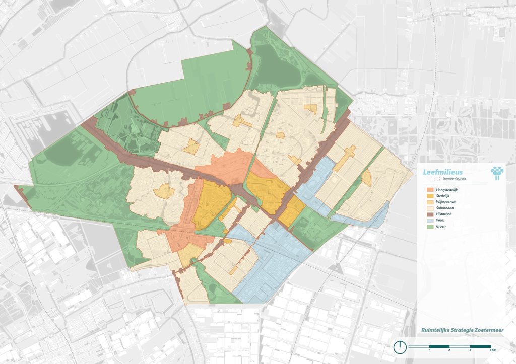
It also distinguishes the different living environments of the city. The living environments indicate how different areas will develop. For each living environment there is a description of different themes such as social, green, mobility and high-rise buildings. The Spatial Strategy also looks to the future beyond 2040.
Environmental impact report (OER).
Simultaneously with the preparation of the Spatial Strategy, an Environmental Impact Report (OER) was drawn up. In this report, various alternatives were examined, and the environmental effects of the choices made in the Spatial Strategy were mapped out. These include environmental effects (e.g. nature, soil, water) but also social and economic aspects (such as health, welfare and accessibility). The results partly influenced the final Spatial Strategy. View the Environmental Impact Report (OER) here.
Views
Between April 4 and May 15, 2025, the draft Spatial Strategy Zoetermeer 2040 and the accompanying Environmental Impact Report were available for inspection. Several views were submitted. All views have been answered by the Municipal Executive in the Memorandum of Reply to Views on the Draft RSP and OER. View the memorandum of reply here.
As part of the public consultation period, the Spatial Strategy and the Environmental Impact Report were also sent to the EIA Committee for its opinion. View the mer committee's advice and the memorandum of reply to the mer committee's advice here.
In response to the views received and the advice of the Mer Committee, the Spatial Strategy and the Environmental Impact Report were improved and tightened in parts.
Participation
There was extensive participation in the creation of the Zoetermeer 2040 Vision and the Spatial Strategy. The pop-up Expo ONS Zoetermeer then, now and later was set up for this purpose. In the Expo, Zoetermeerders could learn about and share information about the developments in the city. They could do this during free visits, but also at organized events, such as (graffiti) workshops andZoetermeerders in gesprek' evenings. More information can be found in the participation report.
View theSpatial Strategy Participation Report here.
City Makers
During the participation and development of the Spatial Strategy, an "Atelier Stadmakers" emerged that actively engaged in thinking about the future of the city. We are grateful to the Atelier Stadmakers for their involvement, thinking along, inspiring and co-organizing. Information about Atelier Stadmakers can be found atstadmakers.nl | Treasurers.
Documents
- Spatial Strategy Zoetermeer 2040 - City in the neighborhood.pdf
- Environmental Impact Report (OER) Spatial Strategy Zoetermeer.pdf
- Memorandum of response to views draft NSSO and OER.pdf
- Mer Committee opinion.pdf
- Memorandum of response to advice of mer committee.pdf
- Participation report Spatial Strategy Zoetermeer.pdf